 Langenes, Barent


 Langenes, Barent
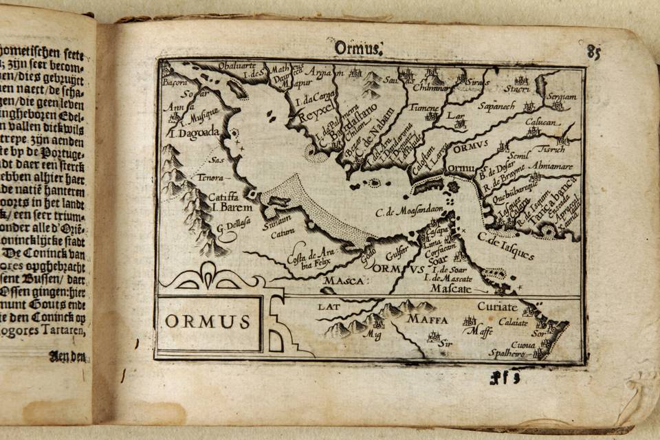
Ormus (Persian Gulf)
Copperplate engraving
Amsterdam, Barent Langenes, 1598
pp 85 and 86 from the atlas, Caert Tresoor
Copperplate engraving, 9x12,3 cm.
Clear print. Unrestored in its original state.
Description of Ormus (see below) is in verso of the map in Dutch.
First map ever printed of the Persian Gulf as a stand alone. Extremely rare as only 13 copes of the original atlas are known to survive. In Sultan al Qasimis book the Langenes map is shown in an c 1610 example by Petrus Bertius. Only in its first edition of 1598 the map is presented without the framework of longitude and latitude, as is our map.
Text in verso of the map: description of Ormus
On the limits of the Persian (Gulf) there is a mighty Kingdom called Ormus. It comprises a part of Persia that is watered by the rivers Tabo; Tuissindo and Druro and some islands at the inlet (of the Persian Gulf) and also a part of the Happy Arabia bordering the same Gulf. The capital is the island Ormus at the entrance of the Gulf, 12 miles out of the coast where the city of that name lies.
That is a beautiful mercantile city, better than any other (city) bordering the sea in the beauty of the place and the number of shops and exceptionally beautiful pearls.
However, there is great scarcity of wheat and sweet water because the island is not fertile and gives no wheat. Thus, everything is transported to them. Trade flourishes there exceptionally and (merchants) come from Arabia; India and Persia. They bring silk; pearls and precious stones.
There is a small mountain on this island that on one side has Sulphur mines, on the other side Salt mines.
The inhabitants are rather beautiful, half Arab, half Persian who eat mainly rice and are lovers of music and the other arts. Their King is a Sarazin (?) and gives every year 15000 Seraphinen (= stones) to the Portuguese. The Portuguese have a strong and well equipped castle there.
Bibliography: Al Qasimi. Sultan Bin Muhammad.
The Gulf in Historic Maps 1493-1931. Thinkprint, Leicester, UK 1996