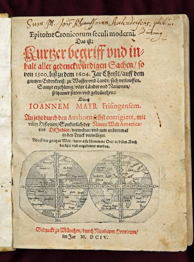
Tabula Anemographica
Augsburg, c. 1740
Copper plate engraving
50x57 cm
In contemporary color
Slightly rumpled and strengthened on the fold.
Still a highly attractive map with each and every wind a name in six languages, starting in Greek and the four seasons as cartouches in each corner of the map.
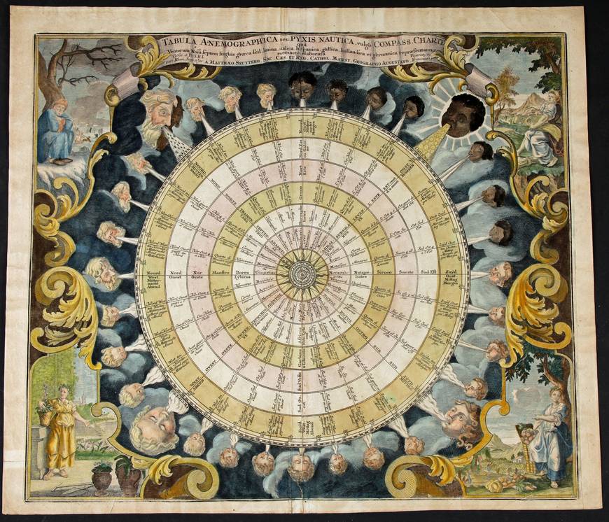
Scenographia mundanae compagis Brahea
Amsterdam, Valk and Schenk 1708
Koeman, Cellarius 3, map 7
Copperplate engraving
42,5x50 cm
Contemporary color
Good, clean condition, strengthened for a few cm at the back of the map to avoid a break of the original copper green.
Later edition by Valk and Schenk of the original Cellarius map from his Harmonia Macrocosmica seu Atlas Universalis et Novus or Atlas Coelestis of
1660. The only change is the name of the author.
Nieuw Aerdsch Pleyn
(1660?) c. 1690 - original colour (Shirley 582)
Rare map of the world made by Robyn/Danckerts and illustrated by Herrewyn. Very nice contemporary colour, which makes it a spectacular map. Showing the world projected from the north pole.
Nova totius terrarum orbis...
Amsterdam, Blaeu 1606 (1621, 1630 and later)
(Schilder: Monumenta VI, map 1-4)
Copper plate engraving
Engraver Joshua van der Ende
41x55 cm
Verso: German text
In contemporary color
Old folds parallel to the center fold straightened out. No restaurations.
Worldmap, planisphere on Mercators projection, surrounded by illustrations. Carte a Figures. This map is iconic and an example of the best of Dutch map making. Originally engraved in 1606 our example is the fourth state. The map opens all Blaeu world atlases from 1534 to 1662 when his son Johan replaced it with an updated, double hemisphere world map.
No title but: Mappa Mundi
Mappa Mundi in Bogars, J.
Gesta Dei per Francos
In second part: Liber Secretorum Fidelium Crucis
Hannover, Wechsel, 1611
Shirley 276; Norderskiold Fig 28
Copperplate engraving, diameter 34x35 cm.
Oriented to the top
Mappa mundi, possibly by Pietro Vesconte, circa 1320 and reproduced in print by Johannn Bongars in 1611. His book was a manual for true crusaders
Medieval circular worldmap, the land mass surrounded by oceans, Jerusalem at the centre. Notable are the rhumb lines, crossing the earth from 16 points at the horizon.
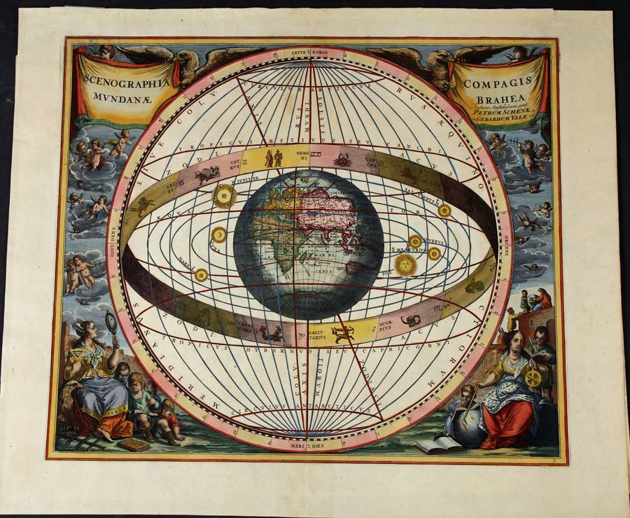
No title: double hemisphere worldmap
Nicolaus Henricum, Munchen 1604
(Shirley, 245)
Copperplate engraving
c. 6x12 cm
B/W
Title page of Mayr s Epitome Cronicorum
The small double hemisphere worldmap is worth studying. It is a copper plate engraving. The prime Meridian is at Tenerife. Both hemispheres are split in quarters by a broad band as meridian and equator which leads to a deformation of the continents. Both Poles consist of land and further North (and South) there is sea again. The map suggests both poles are actually water surrounded by land and ice. The southern Pole, around und under the Circulus Antarcti, comes twice further North than the Tropic of Capricorn, once under N. Guina (sic) and once ...
Generale Ptholemei
Strasbourg, Scott 1513
Shirley 34, plate 37
Woodcut, B/W as issued
No text in verso, no watermark
45x60 cm
Paper corners re-installed not affecting the printed area. Rebacked with two small areas of manuscript completion.
From Claudii Ptolemei, Geographiae opus novissima. One of the most attractive Ptolemaic maps of the world in a conic projection and surrounded by forceful wind (heads).
Preparatory work began in 1505 with his associate Mathias Ringmann. Waldseemüller is believed to have incised many of the maps himself. All are firm, distinctive woodcuts (Shirley, 1987: 38)
(no title but) the World
Freiburg, Scott, 1503
(Shirley, nr 22, state 1)
Woodcut with contemporary color
Watermark: Christian Cross, 32x16 mm
28x42 cm
Rebacked with fine, Japanese paper. Frequent, tiny wormholes, closed. Two tears, also closed. No loss to the printed lines, no installed manuscript.
In spite of the wormholes the map is a beauty and practically unknown with contemporary color.
One of the earliest, post-Ptolemaic worldmaps, surrounded by the twelve wind heads. Important as it shows the transition from Ptolemaic to modern cartography as it developed based on the results of the voyages of discovery. The land mass enclosing the Indian Ocean and connecting Africa with Asia is still there but ...