 Citizen's Association


 Citizen's Association
Report of the Council of Hygiene
Sanitary conditions of New-York
New York, Appleton and Co. 1866
In octavo, contemporary quarter black Morocco
Title in gilt on the spine
2 free blank end leaves; 18 pages;
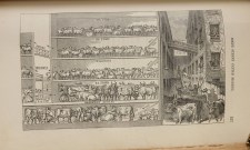
FIRST PART: Title leaf ; Large folding map of New York
pp 21-36: Introduction
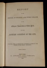
pp 37-144: Report ..on the sanitary condition of the city,
including 5 illustrations
SECOND PART:
pp 1-350: Reports of the sanitary inspectors,
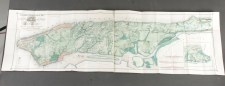
including one folding map and 46 illustrations
pp 351-360: Index
Condition: excellent
This is the second edition (first 1865) of a path breaking public health study by 29 teams in the 29 districts that constituted XIX century New York. It documents the direct relationship between health and poverty and recommends ample measures to control then frequent typhus; cholera; and other contagious diseases. This exemplary study covered all of New York, practically house by house and family by family. The New York Times reported in June 1865:
At last we have a reliable report upon the social condition of New York city. The report does not hinge on hearsay but embraces the social and sanitary history of half a million people. It is an investigation into the causes of diseases and death.
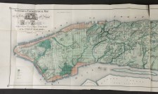
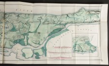
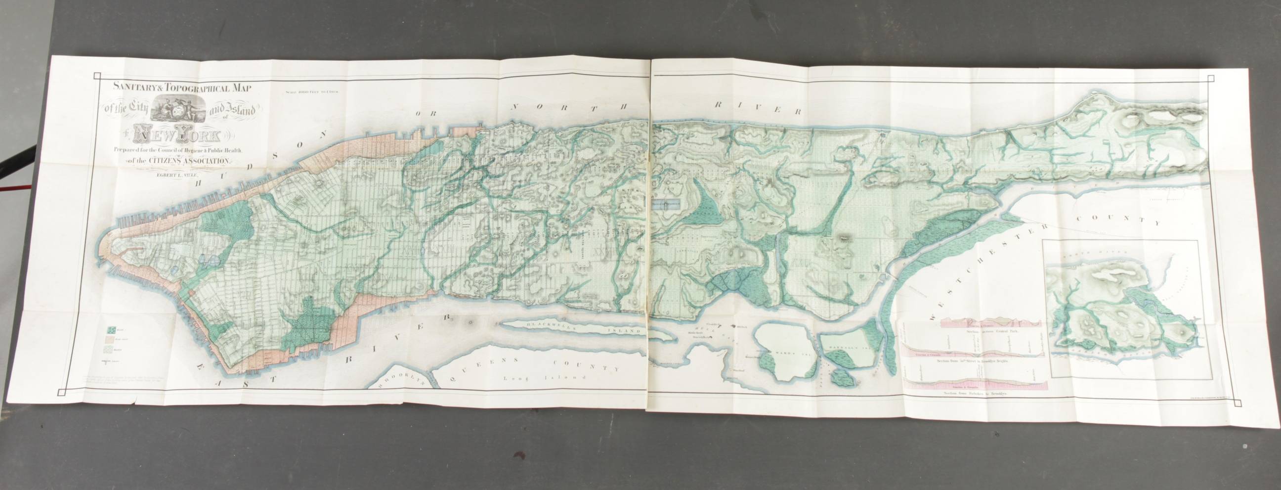
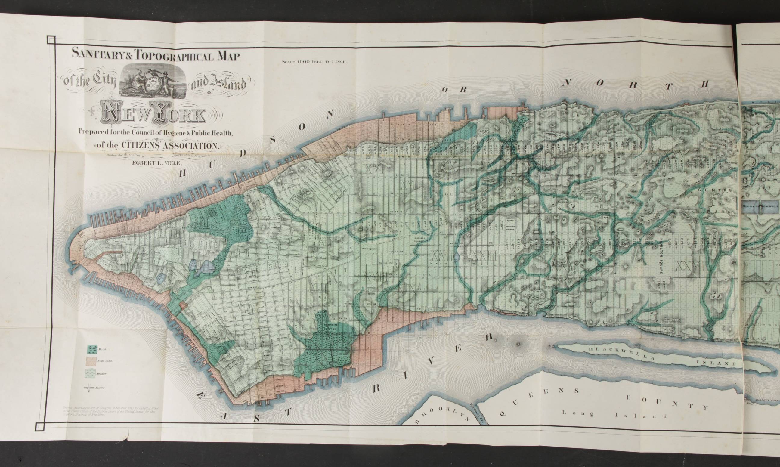
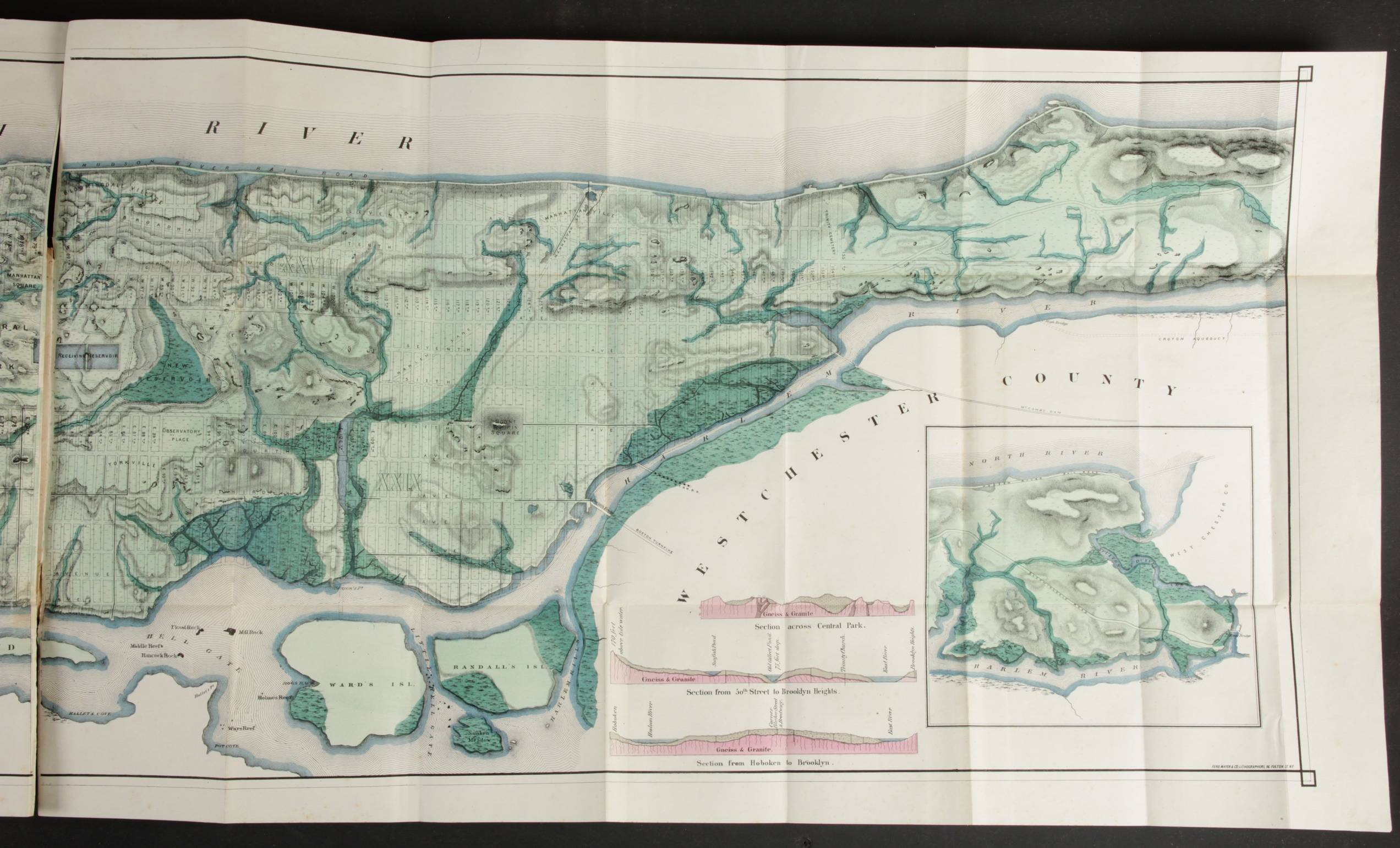
Apart of being a very early example of a population based study of poverty and health in the USA the Report carries two magnificent and important maps. The first is Vieles Sanitary and topographical map of the city and island of New York. It shows Manhattan parcelled up after the final Commissioners Plan of 1821 but, most important all the original water courses, streams (underground and surface), meadows, marshes, ponds, ditches, canals and the shoreline before the landfill... (Augustyn and Cohen, 1997)
The other Sanitary and social chart of the fourth Ward of New York .... measures c 45x58 cm, and is a house by house map of the area between Whitehall , South Street; Old Slip and Beaver street, the South East end of Manhattan.
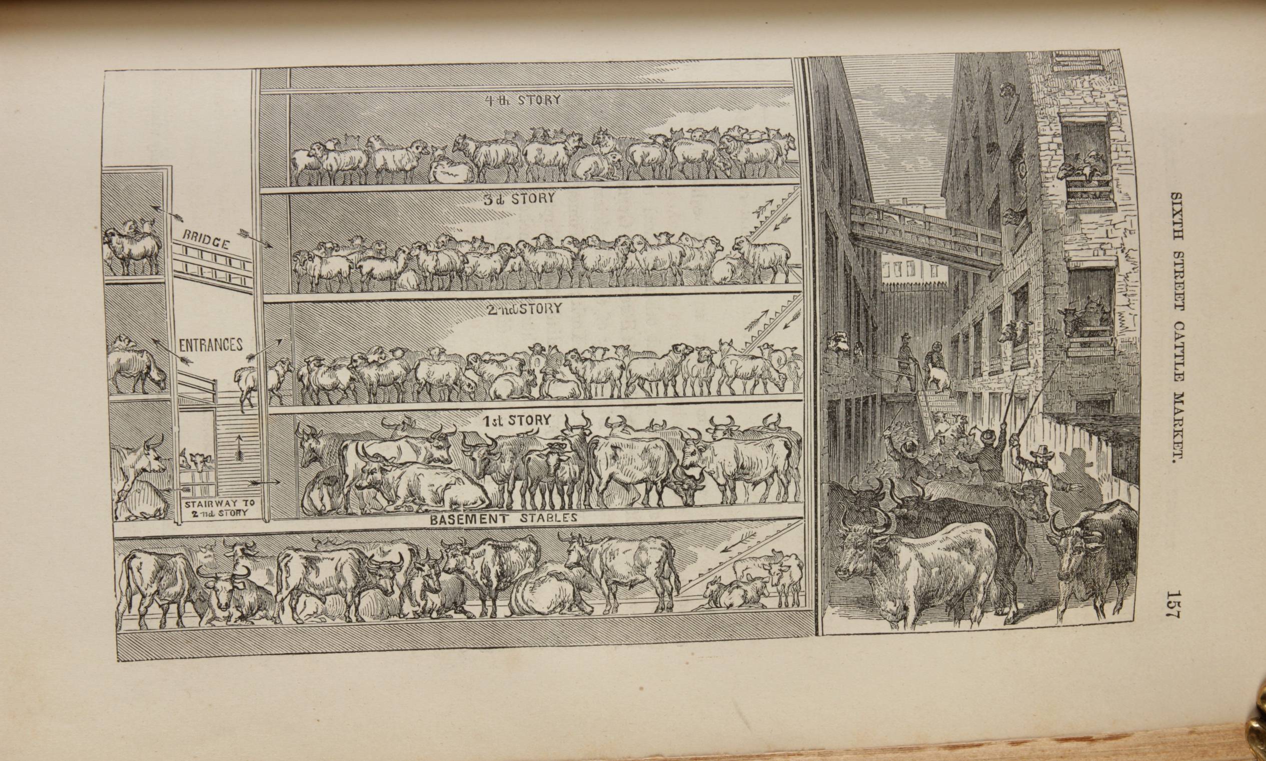
Besides these two maps the book includes like 50 plates, mostly woodcuts after photographs of the day.
Public health significance:
Before the XIX century little knowledge existed on the causes of disease and death and so public interventions were uncommon. Only isolation of infected persons was practiced in American port cities upon arrival and voluntary hospitals were established in the main cities. In the XIX century there was a great sanitary awakening and cleanliness, piety and isolation were introduced as public programmes to fight disease.
This is the second edition (first 1865) of a path breaking public health study by 29 teams in the 29 districts that constituted XIX century New York. It documents the direct relationship between health and poverty and recommends ample measures to control then frequent typhus; cholera; and other contagious diseases. This exemplary study covered all of New York, practically house by house and family by family. The New York Times reported in June 1865:
At last we have a reliable report upon the social condition of New York city. The report does not hinge on hearsay but embraces the social and sanitary history of half a million people. It is an investigation into the causes of diseases and death.
Apart of being a very early example of a population based study of poverty and health in the USA the Report carries two magnificent and important maps. The first is Vieles Sanitary and topographical map of the city and island of New York. It shows Manhattan parcelled up after the final Commissioners Plan of 1821 but, most important all the original water courses, streams (underground and surface), meadows, marshes, ponds, ditches, canals and the shoreline before the landfill... (Augustyn and Cohen, 1997)
The other Sanitary and social chart of the fourth Ward of New York .... measures c 45x58 cm, and is a house by house map of the area between Whitehall , South Street; Old Slip and Beaver street, the South East end of Manhattan.
Egbert L Viele
Sanitary and topographical map of the city and island of New York
New York, Ferdinand Mayer & Co. No date but 1865
Augustyn and Cohen, 1997 p 136 etc
Colored Lithograph in two, separate parts bound into the 1866 second edition of the report. 17,5 by 63 inches (45x160 cm). Printed in strong paper. Fresh appearance, no restorations except for the smallest (one or two inches) tears) at the first folds bound into the book.
Viele took 20 years of surveying to make this map. The first one published in 1857 only covered the lower half of Manhattan, ours the whole island and the 1870 version the same are but in more detail. Viele was convinced that improving sanitary conditions would improve health in the city with 100 percent. As the geographical condition underlaying the grid was perfectly veritable and clear it became a valuable guide to prospective purchasers of property and building.
The most enduring map of Manhattan
Pulling, E R and Randall, F J
Sanitary and social chart of the fourth ward of the city of New York
New York, Appleton & Co. No year but 1865
Colored lithography on thin paper. 20 by 23 inches (46x58 cm). Excellent condition.
Colours indicate conditions of housing (crowding); stables; untenable buildings; privies in extremely offensive condition AND cases of small pox in the past year (3 stars); typhus (2 stars); unsanitary conditions (1 star).