 Ottens, J.


 Ottens, J.
Composite atlas (no title)
Amstelaiedami apud Reinervm et Iosvam Ottens
1730 or shortly afterwards (no date)
Koeman Ott(ens) 1; Cf. Philips 522
Engraved title page, 119 double-page engraved maps of which 14 folded and 6 double-page engravings, all except one coloured in a fine contemporary hand. Special items are:
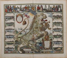
Leo Hollandicus, Comitatus Hollandiae Denua Formâ Leonis, published by Claas Janszoon Visscher and dated "1648" in the plate
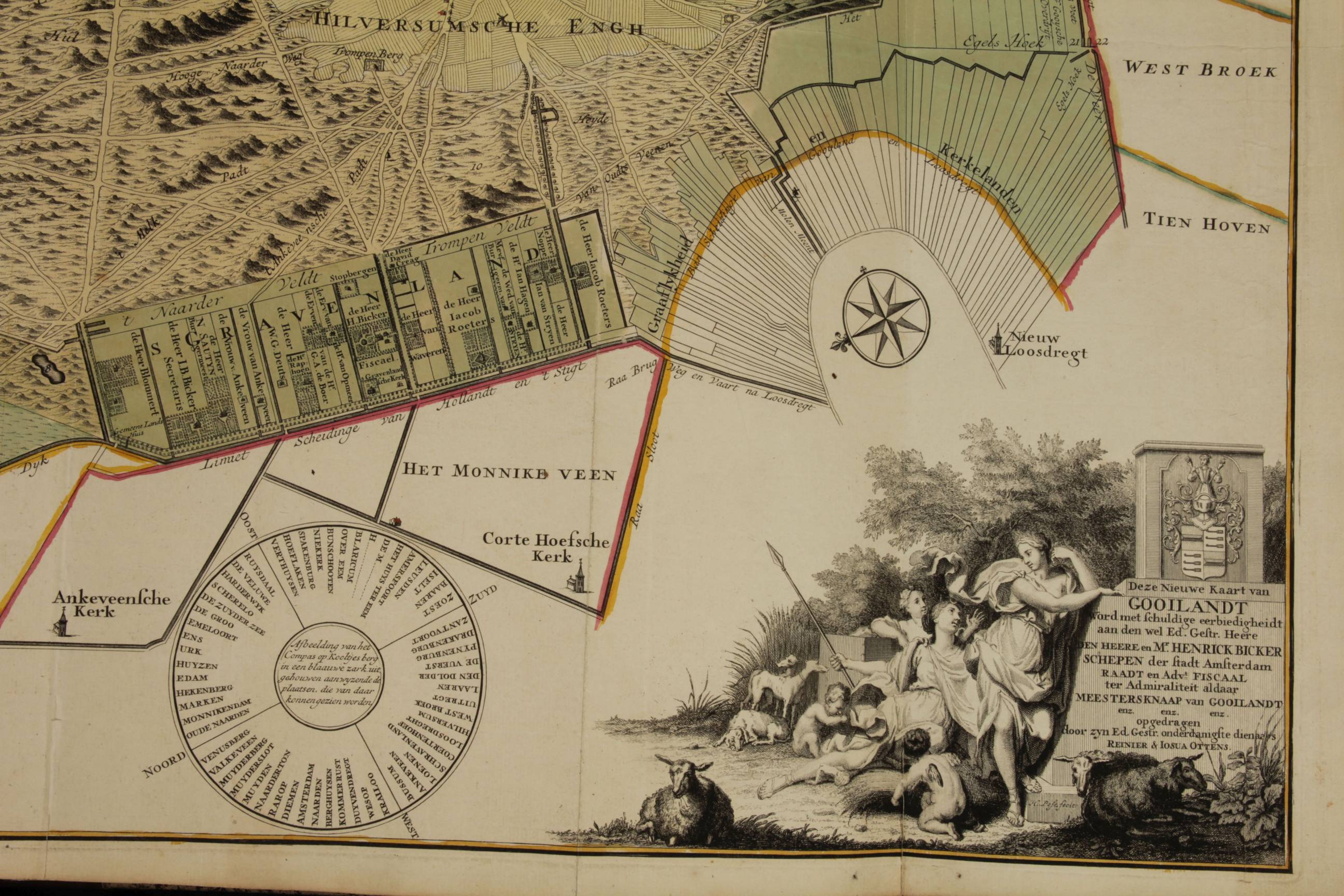
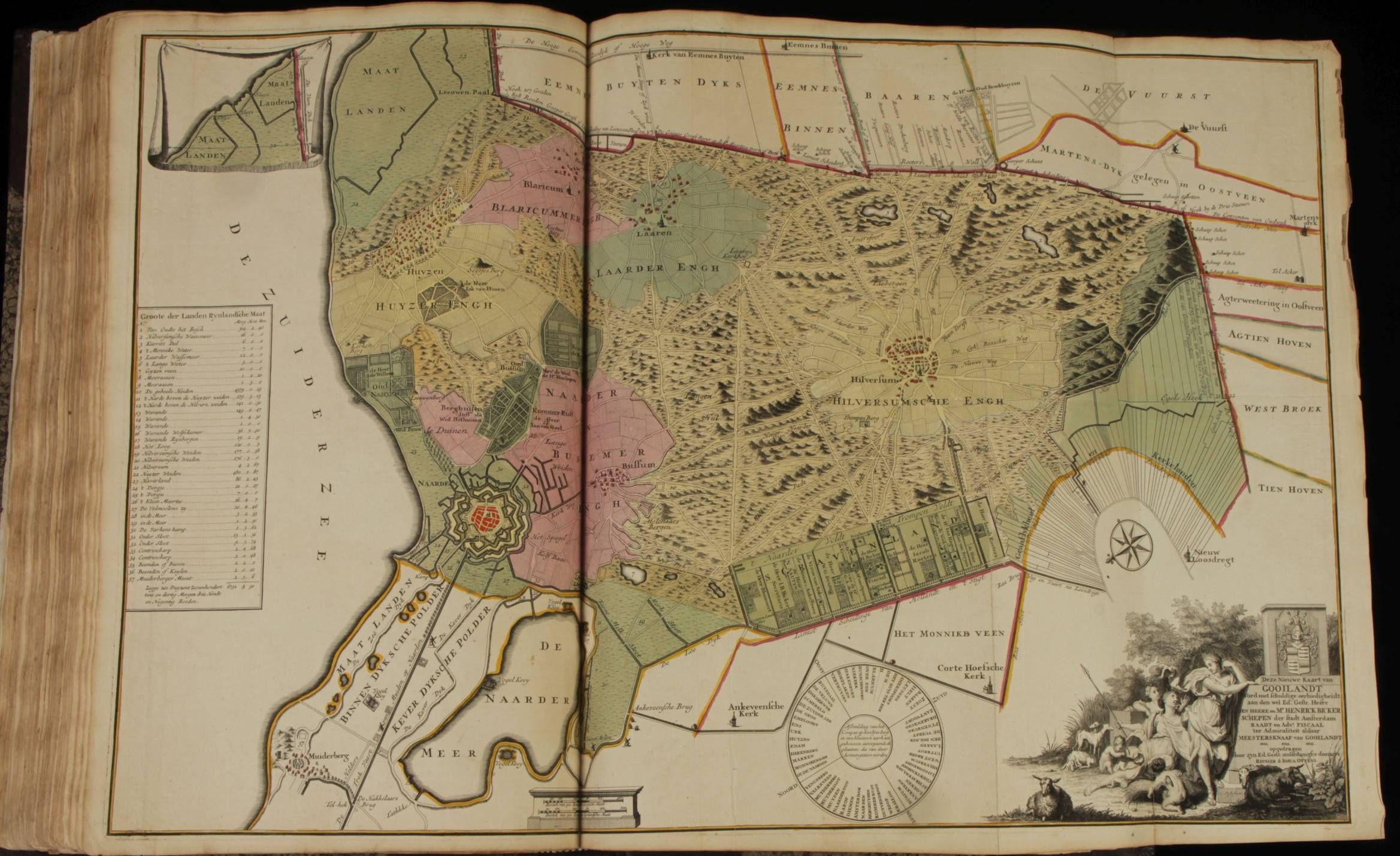
...Nieuwe Kaart van Gooilandt.., Gerrit Post published by R. & J. Ottens, 51x83 cm ca. 1725
Large folio 53,5 x 33 cm, recent binding, made to style.
Rare early 18th-century Dutch composite atlas consisting of maps of Africa (3), Asia (4), Europe (i.a. France (17x), Germany (26x), Italy (8), Low Countries (24x), Scandinavia (4x), Spain/ Portugal (8x) & Turkey(1) and North- & South America (4) for the greater part published in Amsterdam by the Dutch cartographers Reinier Ottens & Josua Ottens. Some of the maps are dated in the plate, the most recent ones in 1730.
Other cartographers included are: Allard; Covens & Mortier; Guillaume De l'Isle, Halma; Pierre Husson ; Jaillot; de Leth, Pieter Mortier, Joachim Ottens (the father), Johannes de Ram, Pieter Schenk, Caspar Specht, Gerard Valk & Leonard Valk, Claes Jansz. Visscher (1587-1652), Nicolaes Visscher I (1618-1679) & Nicolaes Visscher II (1649-1702) and Frederik de Wit.
The firm of father (Joachim) and sons (Reinier and Joshua) flourished between 1719 and 1750. Its greatest fame came from voluminous atlases, assembled to order. Such atlases survive in one volume copies up till 15 volumes!. A sales catalogue of the firm, found in the Hertog August library in Wolfenbüttel offers 236 different maps for sale from over 10 different map makers.
Colouring was a mayor characteristic in all of them. ""If one atlas..had to be nominated as non plus ultra for its colouring, it would be the Ottens atlas in the Teyler museum (Koeman III; 86).
Precise dating of the composite atlas is impossible. Where maps are dated in the plate these vary between 1648 and 1730, most of them between 1710 and 1730. As the firm was active assembling atlases for private clients it is thus reasonable to date the atlas between 1730 and 1750.
That the atlas has been put together for a client by one and the same cartographer/mapseller is also clear. Almost all the maps are coloured by the same hand though they were made by more than a dozen different cartographers. It seems that the Ottens brothers bought the maps in black and white and had them coloured by their own colourist. Typically a few strong colours would be used and the elaborate cartouches would be left black and white. This helps to contrast the scientifically rigorous geography from the often romantic images of the cartouche. The use of these strong colours was started by Schenk and Valk circa 1680 and assumed later by many others, also in Germany (Homann and Seutter). Only two or three maps in the atlas have the cartouches coloured, possibly later.
It would be ideal to identify the first owner who ordered the atlas. There are no hints to be found except for the fact that the atlas includes the map of Gooilandt, a very rare map and a map, coloured in tones, different from the others. It was probably coloured already before it was integrated in the composite atlas. My guess would thus be that the composer/owner of the atlas was Dutch and lived in het Gooi.