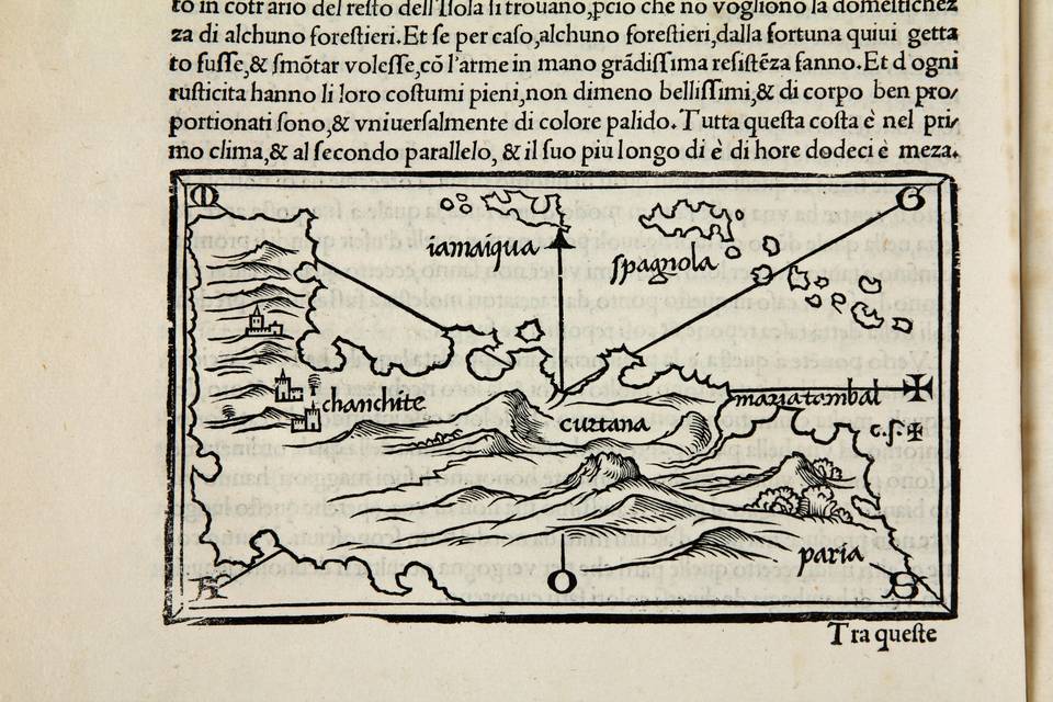
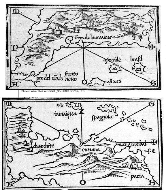
Isolario di Benedetto Bordone..
Isolario di Benedetto Bordone..
de tutte lIsole del mondo...
Venice, Aristotele (=Zoppino) , 1534
(Shirley 59; Ginsberg, Scandinavia, map 7; Burden, map 8: Suarez, Shedding the veil, pp 66/67; Harrisse Vetustissima no. 187
In folio, XIX quarter vellum
10 nn leaves; 74 folios
Title in engraved scrolls printed in red and black
Second edition of this important atlas, published in June 1534.The atlas includes the first edition of the oldest known report on Pizarros conquest of Peru and his victory over the Incas on March 15, 1533.
The modern ...
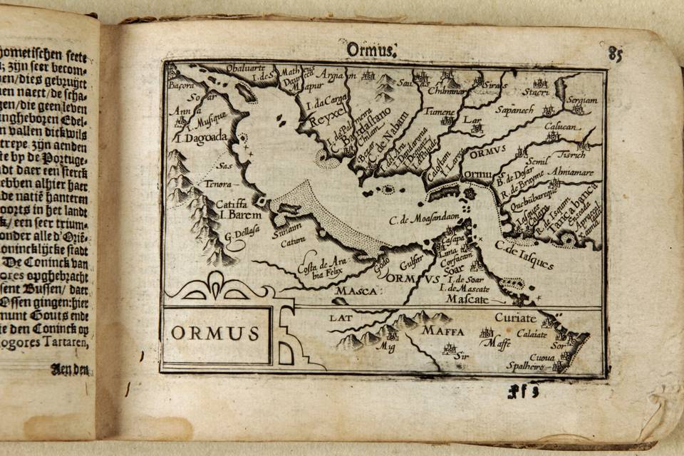
Ormus (Persian Gulf)
Copperplate engraving
Amsterdam, Barent Langenes, 1598
pp 85 and 86 from the atlas, Caert Tresoor
Copperplate engraving, 9x12,3 cm.
Clear print. Unrestored in its original state.
Description of Ormus (see below) is in verso of the map in Dutch.
First map ever printed of the Persian Gulf as a stand alone. Extremely rare as only 13 copes of the original atlas are known to survive. In Sultan al Qasimis book the Langenes map is shown in an c 1610 example by Petrus Bertius. Only in its first edition of 1598 the map is presented without the framework of longitude and latitude, as is our map.
Text in verso of the map: description of Ormus
...
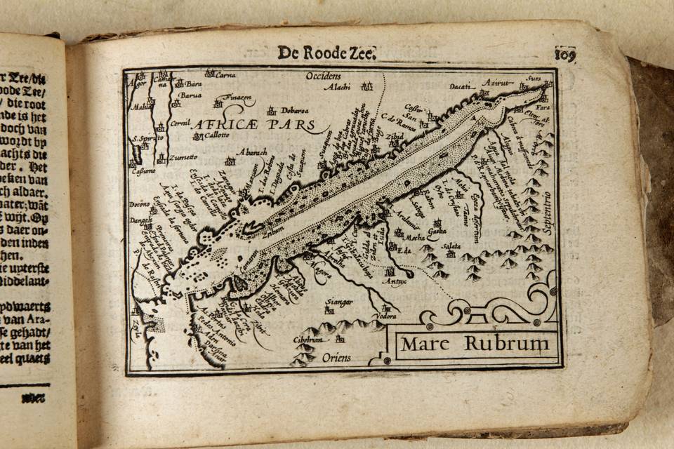
Mare Rubrum
From the atlas, Caert Tresoor,
Middelburg, the Netherlands, 1598
Tibbetts 1978, map 56
B/W as issued, 9x12,3cm
The first map exclusively dedicated Arabia and the Red Sea is in the Ptolemy edition, in Rome of 1478. It is called Sexta Asiae tabula. The first modern depiction of Arabia and the Red Sea is in Waldseemullers Carta Marina of 1516 of which one copy only is known to exist. The first printed modern map of Arabia and the Red Sea is Arabia Felix Nova Tabula by Gastaldi in 1548. Tibbets calls the Gastaldi 1548 map the first printed map to specifically deal with Arabia. That map was copied and enlarged by Ruscelli in 1561.
In that same year, 1561 Gastaldi produced a larger map ...seconda parte ...
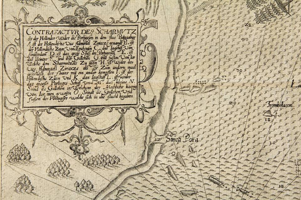
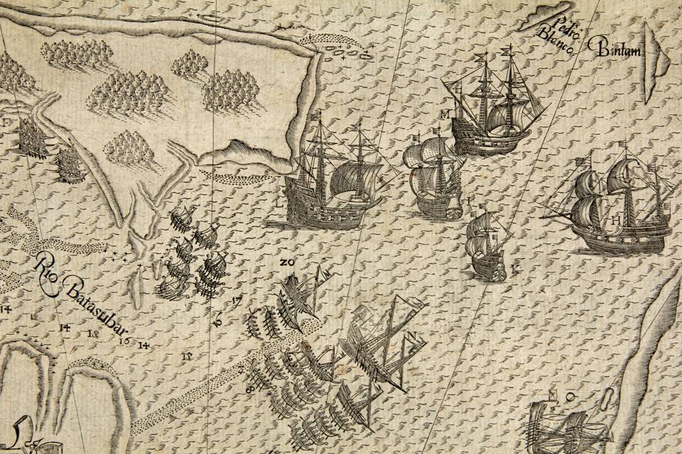
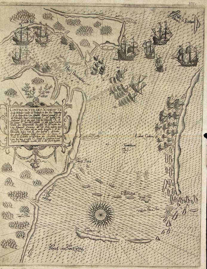
Contrafactur des Scharmutz
In part VIII of the Petits Voyages,
Latin version
Johann Theodor and Johann Israel de Bry,
Frankfurt 1607
(Suarez, Mapping of SE Asia, Periplus 1999: 184; Church 218)
Copper plate engraving, 33x26 cm,
Small margins (circa 1 cm), good print, no restorations
This map (plate XIII) comes from the Latin version of the Petits Voyages, part VIII, published by de Bry in 1607. It is the oldest surviving printed map showing Singapore. It came out in identical form in the German version of the same de Bry volume, published in 1606
The north is to the left. The map shows Sinca Pora with the Batasubar (Johor) river to the east. The Sea, south of Sinca Pora is more ...
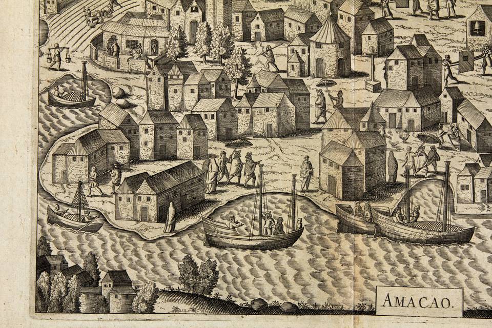
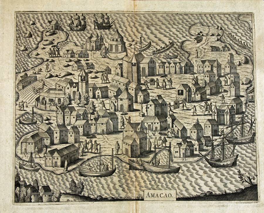
Amacao
From the Petits Voyages, book VIII
latin edition
Frankfurt, de Bry sons. 1607
Copper plate engraving
25,5x 32,5 cm
Ample margins, no restorations
Wattis fine art. Early views and maps of Macau, 1570-1890. Hong Kong May 1999
The Portuguese were the first to depict Macao in the West. These were unique drawings, not prints. The oldest manuscript images that I am aware of are in a 1636 album by Antonio de Mariz Carneiro. I add an image where you can see the development over time in building fortifications at strategic points on the peninsula.
De Bry in his Petits Voyages, publishes an engraved view of the city, a nice and convincing birds ...
Carte generale du cours du Gange et du Gagra
Paris, Du Perron. 1784
(Gole, 1983: 102 2.1; Sommervogel, Vol VIII, column 21 & 22; Edney p 133) 59x75 cm, black & white as issued, copper plate engraving. Slight, overall browning. Else fine
A rare and fundamental map in the history of cartography of India.
Tieffentaller (born 1710) was a Jesuit who worked and travelled India (1742-1785). He used his knowledge of the higher Ganges area to draw this map, which was published in Paris in 1784 and used by Rennell for his pioneering work on the cartography of that country. Notably but not surprisingly for a Jesuit he used and ...

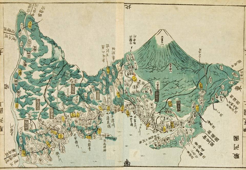
Suruga (Mount Fuji)
Woodcut map, printed in rice paper.
Colored in two more goes of other woodblocks with color: green and yellow
Apart from being informative and beautiful the map stands out using two and three dimensions in one and the same print. The province is shown in two dimensions emerging into a third dimension: mount Fuji.